Moscow planned to turn the Kazakh steppe into a cotton empire, drained the world's fourth-largest lake in forty years and left an entire fishing fleet rusting in the desert
In the 1950s, Soviet planners decided that the Aral Sea was a problem to be solved. Two rivers flowed into it and were being wasted on a body of water nobody needed when cotton fields could be watered instead. It was one of the most consequential engineering decisions of the twentieth century, and the lake disappearance that followed became one of its greatest environmental catastrophes.
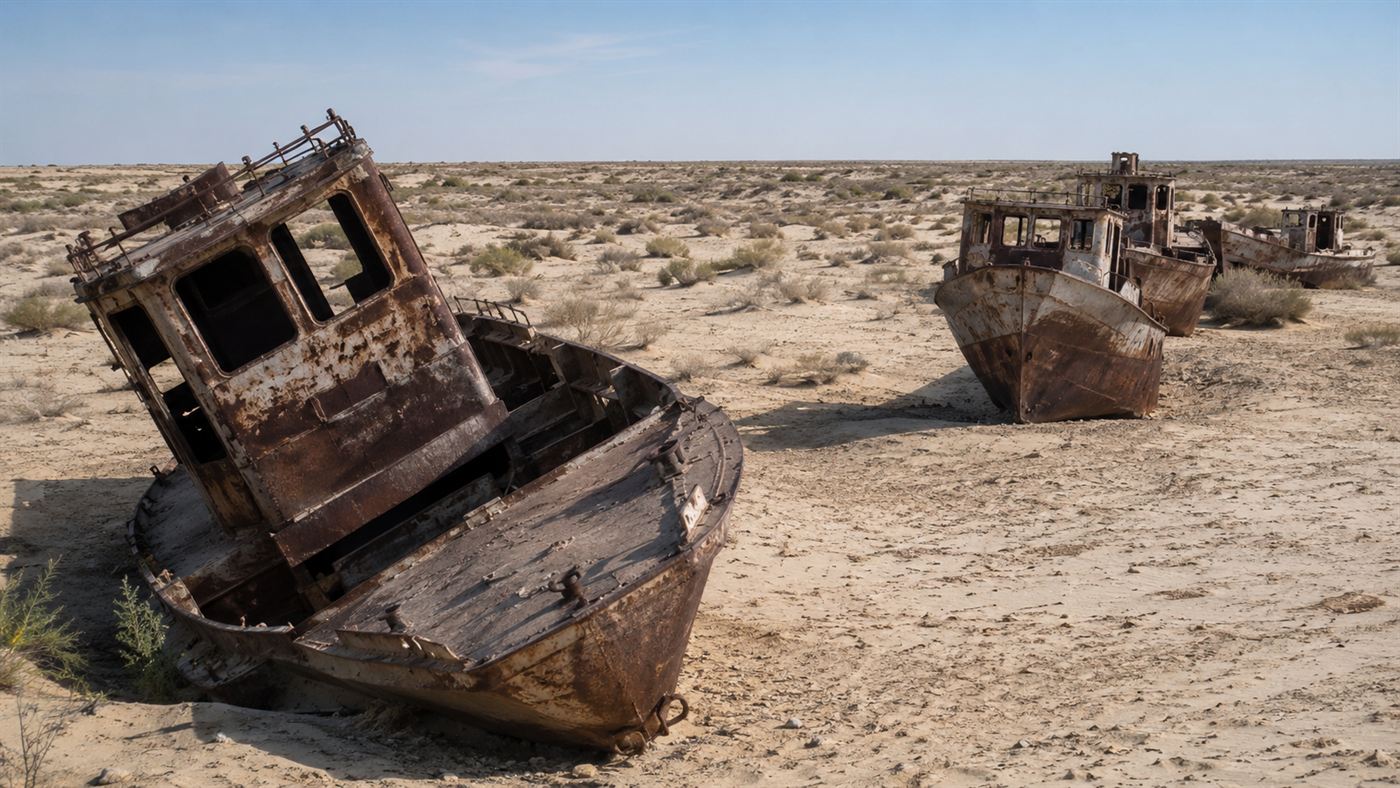
The ship graveyard outside Moynaq, Uzbekistan. These vessels fished the Aral Sea in the 1960s. By the 1980s the water had retreated so far that the port no longer existed. Illustration: Watts & Wild.
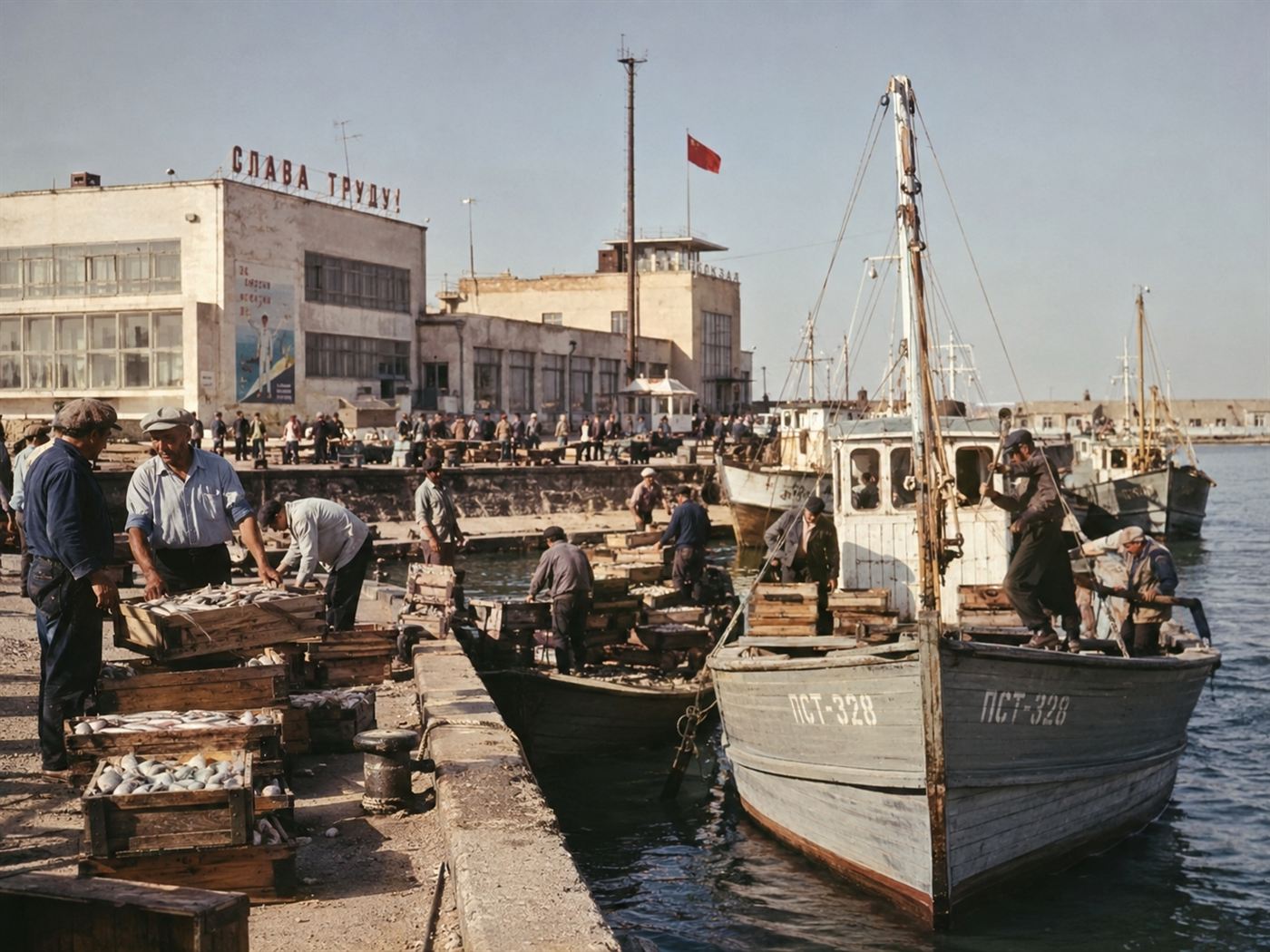
The Aral Sea once covered 68,000 square kilometres, roughly the size of Ireland, in what is now Uzbekistan and Kazakhstan. It was the world's fourth-largest lake, so large that the fishing industry it supported employed 60,000 people across the region. The town of Moynaq, on its southern shore, was a thriving port with fish canneries, a hospital, schools, and a small airport.
Today the canneries are closed, the port is 150 kilometres from water, and NASA's satellite record shows that the southern half of the Aral Sea has essentially ceased to exist, replaced by a white expanse of salt, dust and pesticide residue that blows across Central Asia in toxic storms. The ships that once sailed out of Moynaq are stranded in the sand, rusting slowly into the landscape they used to float above.
The Soviet decision that redirected two rivers and set the clock ticking
The Aral Sea was fed by two rivers: the Amu Darya, flowing down from the Pamir Mountains, and the Syr Darya, carrying snowmelt from the Tian Shan range.
In the 1950s, under Nikita Khrushchev, Soviet planners launched an ambitious programme to turn the arid steppes of Central Asia into the USSR's primary cotton-growing region.
To do it, they needed water on a massive scale.
The solution was to tap the Amu Darya and Syr Darya through an enormous network of canals, sluices and irrigation channels that would divert their flow away from the Aral Sea and onto the cotton fields of Uzbekistan, Turkmenistan and Kazakhstan.
The Karakum Canal, begun in 1954 and stretching more than 1,300 kilometres, was the centrepiece of the effort.
By the 1960s, the canal system was diverting the majority of both rivers' flow before it ever reached the Aral Sea.
Soviet engineers understood that the lake would shrink.
The plan assumed that was acceptable, even desirable: a sea nobody was sailing across for commerce was simply a reservoir being evaporated by the Central Asian sun, and the cotton it would nourish was a strategic necessity in the Cold War economy.
What they did not account for was the speed of the collapse, or what a 90% reduction in volume would leave behind.
What the fishermen of Moynaq watched happen to their port
In 1960 the Aral Sea held roughly 1,000 cubic kilometres of water.
By 1980, the water level had dropped by 14 metres and the shoreline had pulled back by tens of kilometres.
The fish canneries in Moynaq had already begun trucking in fish from the Caspian Sea, 2,000 kilometres away, because the local catch had collapsed along with the lake's salinity rose from 10 grams per litre to over 45, well beyond what most freshwater species could survive.
By the 1990s, the lake had split into two separate bodies: the North Aral Sea, still fed by a trickle of the Syr Darya in Kazakhstan, and the South Aral Sea, in Uzbekistan, which was receiving almost nothing from the Amu Darya.
The fishing fleet was beached in what had become desert.
The crews who once sailed it had scattered to find work elsewhere, their industry gone, their port landlocked, their town left with little reason to exist.
The toxic desert and the health crisis nobody predicted
As the Aral Sea shrank, it left behind something the planners had not modelled: a 40,000-square-kilometre salt flat soaked in the residue of decades of cotton monoculture.
The irrigation canals that drained the rivers had also flushed pesticides, fertilisers and defoliants back into the lake bed.
When the water retreated, it exposed all of it.
The wind picks up the salt and chemical dust and carries it hundreds of kilometres across the region, coating crops, contaminating drinking water and settling in the lungs of people who have lived in the area for generations.
In the Karakalpakstan region of Uzbekistan, directly downwind, rates of throat and oesophageal cancer rose sharply from the 1980s onward.
Respiratory illness, anaemia and infant mortality all followed the same trajectory as the lake's retreat.
The exposed lake bed is now called the Aralkum, a new desert that did not exist sixty years ago, and it is one of the youngest and most toxic deserts on Earth.
Philip Micklin of Western Michigan University, who has studied the Aral Sea disaster for four decades, estimated in his 2007 review in the Annual Review of Earth and Planetary Sciences that the loss of the lake's moderating effect on the regional climate has already extended the winter cold season and shortened the summer growing season across Central Asia, compounding the damage to local farming.
The North Aral Sea started coming back
Not all of the story is irreversible.
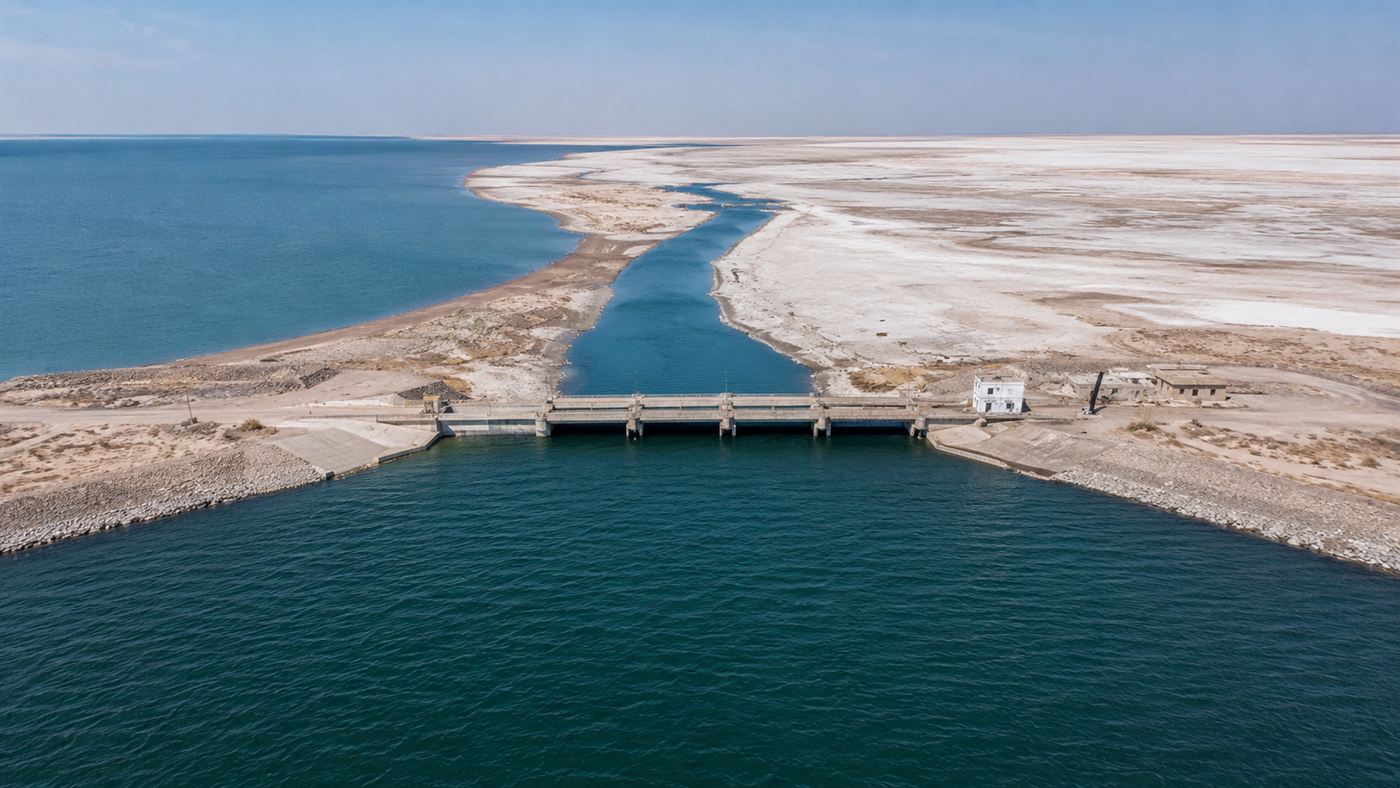
Kazakhstan, which controls the northern remnant of the Aral Sea, built the Kokaral Dam across the Berg Strait in 2005 with World Bank funding, separating the North Aral from the southern basin and allowing the Syr Darya's flow to accumulate rather than drain away.
Within a year and a half the water level in the North Aral had risen by more than three metres.
Salinity dropped from around 30 grams per litre to under 10, close to the level that freshwater fish can tolerate.
Fish returned, then fishing boats, then fishermen.
By the 2010s the North Aral's shoreline had advanced back toward Aralsk, the Kazakh port town that had not seen water since the 1970s, and the small-scale fishing industry had restarted.
It is one of the more unexpected environmental turnarounds of the twenty-first century: a partial resurrection driven by a single concrete dam 13 kilometres long and a decision to stop treating the remnant of a ruined sea as a disposal pond.
The honest catch
The North Aral's recovery is real but limited.
It covers a fraction of the original lake, and it survives because Kazakhstan built a dam to isolate it from the even more depleted South Aral.
The South Aral Sea, the larger of the two basins and the one bordering Uzbekistan, has continued to shrink almost to nothing.
As of the 2020s, it is effectively a series of small, disconnected, hypersaline pools.
Uzbekistan, which controls the Amu Darya's flow, has not committed to a comparable restoration programme.
Cotton is still grown at large scale in Uzbekistan and Turkmenistan, though both countries have begun reducing acreage and shifting to drip irrigation under international pressure.
The Aralkum desert is not going anywhere on any timescale that matters to the people who breathe its dust today.
And the original lake, the fourth-largest in the world, the Aral Sea that supported 60,000 jobs and moderated the climate of a region the size of Western Europe, is not coming back.
What planners in Moscow treated as an acceptable side effect of cotton production turned out to be one of the largest lake disappearances in recorded human history, and the communities who lived on its shores paid a price that was never factored into any five-year plan.
The Kazakh half of the Aral Sea has shown that the damage is not entirely permanent, but the Uzbek half has shown that recovery requires political will as much as engineering. If you could redirect one river in Central Asia to reverse a single piece of this disaster, which one would you choose, and what would you be willing to give up to do it? Tell us in the comments.